|
|
|
|
|
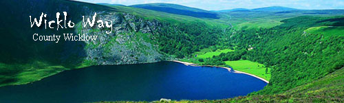
Hiking - Wicklow Way
Wicklow
Ireland
The Wicklow Way is a long distance walking route of 132 km (83 miles) following a north-south route from north Couinty Wexford, through County Wicklow and the Wicklow Mountains to the southern suburbs of Dublin City. The Wicklow Mountains offer superb and challenging walking routes.
The name Wicklow comes from the Viking “Wykynlo” or “Viking’s Loch” referring to the town of Wicklow, one of their favourite bases on the Irish coast. The Gaelic “Cill Mhantáin” translates to the “Church of St. Mantan”. From the border with county Dublin, the mountains cover the middle and west of the county, running south to the Wexford border. The highest point is Lugnaquilla at 926m.
Rounded during the last Ice Age, the hills are smooth with granite bases and shiny schists poking through, to give them a wonderful silvery light. The Ice Age also produced wonderful deep valleys – Glenmacanass, Glenmalure, Glendalough, which run northwest to southeast, providing not only wonderful views but also plenty of legwork for the aspiring walker!
Good pastureland forms the east of the county to the relatively gentle coastline.
The total route is 132km and was the brainchild of a Dublin hill walker J.B. Malone. The Way opened in 1981 and is one of the best managed routes in the country, thanks to the Wicklow Uplands Council and local landowners. It is a pleasure to walk, well signposted, with rougher sections of the track graded to prevent erosion.
The central section is covered by the Wicklow Mountains National Park – its headquarters are in Glendalough and worth a visit. The route follows on occasion the Military Road, constructed by the British in the early 19th century to gain access to the lower regions of the county!
The Way uses forest paths and minor roads in places to avoid walking on private land. However, it is little enough not to detract from the superb scenery, rugged narrow valleys and spectacular mountains. The route doesn’t pass through many towns or villages, so most of the day to day walking is remote. Approximately 20% of the route is on tarred roads. We offer the Wicklow Way from south to north, starting in the lower farming countryside and working up to the higher hills. This also allows for an easy transfer back to Dublin city at the end of your walking tour.
Tour Highlights
- Rural farming communities, farming by day and hosting walkers by night! Come in April for lambing…
- Glendalough & St. Kevin.
- Rivers, lakes and valleys, Glenmalure, Glendasan, Glenalo, Glenmacanass, Lough Tay, Lough Dan, Avonbeg, Avonmore, Cloghoge and Dargle.
|
Walking Tour
Meeting:
Bunclody or Drumgoff
Airport:
Dublin
Transfer:
|
|
|
|
Rates and Dates for 2024
Rates include:
Accommodation; All breakfasts; Luggage transfers; Detailed route descriptions and 1:50000 maps
| A | 2024 | 10 day Self Guided trip | 10d / 9n | €945 | $1040 |
| Single supplement | €395 | $435 |
| B | 2024 | 8 day Self Guided trip | 8d / 7n | €735 | $810 |
| Single supplement | €305 | $335 |
| C | 2024 | 6 day Self Guided trip | 6d / 5n | €525 | $580 |
| Single supplement | €220 | $240 |
�����������������������������������������������������������������������������������������������������������������������������������������������������������������������������������������������������������������������������������������������������������������������������������������������������������������������������������������������������������������������������������������������������������������������������������������������������������������������������������������������������������������������������������������������������������������������������������������������������������������������������������������������������������������������������������������������������������������������������������������������������������������������������������������������������������������������������������������������������������������������������������������������������������������������������������������������������������������������������������������������������������������������������������������������������������������������������������������������������������������������������������������������������������������������������������������������������������������������������������������������������������������������������������������������������������������������������������������������������������������������������������������������������������������������������������������������������������������������������������������������������������������������������������������������������������������������������������������������������������������������������������������������������������������������������������������������������������������������������������������������������������������������������������������������������������������������������������������������������������������������������������������������������������������������������������������������������������������������������������������������������������������������������������������������������������������������������������������������������������������������������������������������������������������������������������������������������������������������������������������������������������������������������������������������������������������������������������������������������������������������������������������������������������������������������������������������������������������������������������������������������������������������������������������������������������������������������������������������������������������������������������������������������������������������������������������������������������������������������������������������������������������������������������������������������������������������������������������������������������������������������������������������������������������������������������������������������������������������������������������������������������������������������������������������������������������������������������������������������������������������������������������������������������������������������������������������������������������������������������������������������������������������������������������������������������������������������������������������������������������������������������������������������������������������������������������������������������������������������������������������������������������������������������������������������������������������������������������������������������������������������������������������������������������������������������������������������������������������������������������������������������������������������������������������������������������������������������������������������������������������������������������������������������������������������������������������������������������������������������������������������������������������������������������������������������������������������������������������������������������������������������������������������������������������������������������������������������������������������������������������������������������������������������������������������������������������������������������������������������������������������������������������������������������������������������������������������������������������������������������������������������������������������������������������������������������������������������������������������������������������������������������������������������������������������������������������������������������������������������������������������������������������������������������������������������������������������������������������������������������������������������������������������������������������������������������������������������������������������������������������������������������������������������������������������������������������������������������������������������������������������������������������������������������������������������������������������������������������������������������������������������������������������������������������������������������������������������������������������������������������������������������������������������������������������������������������������������������������������������������������������������������������������������������������������������������������������������������������������������������������������������������������������������������������������������������������������������������������������������������������������������������������������������������������������������������������������������������������������������������������������������������������������������������������������������������������������������������������������������������������������������������������������������������������������������������������������������������������������������������������������������������������������������������������������������������������������������������������������������������������������������������������������������������������������������������������������������������������������������������������������������������������������������������������������������������������������������������������������������������������������������������������������������������������������������������������������������������������������������������������������������������������������������������������������������������������������������������������������������������������������������������������������������������������������������������������������������������������������������������������������������������������������������������������������������������������������������������������������������������������������������������������������������������������������������������������������������������������������������������������������������������������������������������������������������������������������������������������������������������������������������������������������������������������������������������������������������������������������������������������������������������������������������������������������������������������������������������������������������������������������������������������������������������������������������������������������������������������������������������������������������������������������������������������������������������������������������������������������������������������������������������������������������������������������������������������������������������������������������������������������������������������������������������������������������������������������������������������������������������������������������������������������������������������������������������������������������������������������������������������������������������������������������������������������������������������������������������������������������������������������������������������������������������������������������������������������������������������������������������������������������������������������������������������������������������������������������������������������������������������������������������������������������������������������������������������������������������������������������������������������������������������������������������������������������������������������������������������������������������������������������������������������������������������������������������������������������������������������������������������������������������������������������������������������������������������������������������������������������������������������������������������������������������������������������������������������������������������������������������������������������������������������������������������������������������������������������������������������������������������������������������������������������������������������������������������������������������������������������������������������������������������������������������������������������������������������������������������������������������������������������������������������������������������������������������������������������������������������������������������������������������������������������������������������������������������������������������������������������������������������������������������������������������������������������������������������������������������������������������������������������������������������������������������������������������������������������������������������������������������������������������������������������������������������������������������������������������������������������������������������������������������������������������������������������������������������������������������������������������������������������������������������������������������������������������������������������������������������������������������������������������������������������������������������������������������������������������������������������������������������������������������������������������������������������������������������������������������������������������������������������������������������������������������������������������������������������������������������������������������������������������������������������������������������������������������������������������������������������������������������������������������������������������������������������������������������������������������������������������������������������������������������������������������������������������������������������������������������������������������������������������������������������������������������������������������������������������������������������������������������������������������������������������������������������������������������������������������������������������������������������������������������������������������������������������������������������������������������������������������������������������������������������������������������������������������������������������������������������������������������������������������������������������������������������������������������������������������������������������������������������������������������������������������������������������������������������������������������������������������������������������������������������������������������������������������������������������������������������������������������������������������������������������������������������������������������������������������������������������������������������������������������������������������������������������������������������������������������������������������������������������������������������������������������������������������������������������������������������������������������������������������������������������������������������������������������������������������������������������������������������������������������������������������������������������������������������������������������������������������������������������������������������������������������������������������������������������������������������������������������������������������������������������������������������������������������������������������������������������������������������������������������������������������������������������������������������������������������������������������������������������������������������������������������������������������������������������������������������������������������������������������������������������������������������������������������������������������������������������������������������������������������������������������������������������������������������������������������������������������������������������������������������������������������������������������������������������������������������������������������������������������������������������������������������������������������������������������������������������������������������������������������������������������������������������������������������������������������������������������������������������������������������������������������������������������������������������������������������������������������������������������������������������������������������������������������������������������������������������������������������������������������������������������������������������������������������������������������������������������������������������������������������������������������������������������������������������������������������������������������������������������������������������������������������������������������������������������������������������������������������������������������������������������������������������������������������������������������������������������������������������������������������������������������������������������������������������������������������������������������������������������������������������������������������������������������������������������������������������������������������������������������������������������������������������������������������������������������������������������������������������������������������������������������������������������������������������������������������������������������������������������������������������������������������������������������������������������������������������������������������������������������������������������������������������������������������������������������������������������������������������������������������������������������������������������������������������������������������������������������������������������������������������������������������������������������������������������������������������������������������������������������������������������������������������������������������������������
Rates Note:
A transfer supplement will be added to tours when accommodation in our usual guesthouses is not available. We will of course advise you if this is the only available option to secure a booking.
Transfer and Other Charges:
|
2024
|
Transfers are not available - Make your own way to the start of your tour
|
|
| A |
2024
|
04/03
- 10/15
|
10d / 9n
|
10 day Self Guided trip
|
2
|
Reserve
|
| B |
2024
|
04/03
- 10/15
|
8d / 7n
|
8 day Self Guided trip
|
2
|
Reserve
|
| C |
2024
|
04/03
- 10/15
|
6d / 5n
|
6 day Self Guided trip
|
2
|
Reserve
|
|
Any time during the season.
Rates do not include:
All lunches and dinners; Transfers before and after tour & Entrance fees
Sample Itinerary: 10-day tour - subject to changes
Note: It is also possible to sign up for a shorter tour (8 days or 6 days). It is also possible to extend this itinerary to complete the Wicklow Way walk at Marlay Park in south Co. Dublin. Please do enquire if you are interested!
Day 1: Travel to Bunclody
Make your own way to Bunclody, a pretty town on the banks of the river Slaney.
Overnight in Bunclody
Meals Included: none
Day 2: Clonegal to Shillelagh
Your host will transfer you to Clonegal, the start of the Wicklow Way. Walking is on country roads through Newry forest, Moilishe and Stookeen Hill, into the town land of Mungaculin.
Your accommodation for the night will be in the 17th century village of Shillelagh origin of the Irish walking stick cut from the blackthorn tree, “The Shillelagh”.
Walking Distance 23 km (about 6 hours) / Ascent 120 m
Overnight in Shillelagh or Bunclody
Meals Included: Breakfast
Day 3: Shillelagh to Moyne
From Stranakelly, return to country roads past the market town of Tinahely on the banks of the river Derry which was destroyed in the 1798 rebellion, subsequently rebuilt and found a new lease of life with the coming of the railway in 1865. This section of the Wicklow Way takes in some fantastic views back over the area that you have passed through, and the adjacent counties of Carlow and Wexford; it also passes through an old Ring Fort or Fairy Fort.
With Ballycumber Hill 20km. Ascents 400m. Approximate walking time 6 hours.
Walking Distance 18 km (about 5 hours) / Ascent 100 m
Overnight in farm guesthouse in Moyne
Meals Included: Breakfast
Day 4: Moyne to Drumgoff (Glenmalure)
Good climbing today through the pine forests of the Ow Valley. Drumgoff at the head of the picturesque Glenmalure Valley, provides a refreshing end to the day at the old coaching inn, Glenmalure Lodge. The area is renowned for its rebels and heroes during the 16th and 18th century Irish uprisings. The optional route over Croaghanmoira climbs to 664m and affords glorious views of the Ow and Avonbeg river valleys.
Optional route, Croaghanmoira Hill Ascents 850m, approx. walking time 6 hours
Walking Distance 21 km (about 6 hours) / Ascent 500 m
Overnight in Drumgoff
Meals Included: Breakfast
Day 5: Free Day in Drumgoff
The valley route takes you through pine forest initially for wonderful views of the deep gorge of the Avonbeg river on the eastern flank of Lugnaquilla, the highest point in the area. The descent follows Carrawaystick Brook as it drains the lough into the Avonbeg 450m below. Carriglineen is an easier route for a good walk coupled with some relaxation at the Lodge!
Ascents of Lugnaquilla are for the experienced hiker and would also start from Glenmalure.
Carriglineen Mountain: 8.5 km (approx. 3 hours) / Ascent 330 m
Glenmalure Valley: 12 km (approx. 5 hours) / Ascents 60 0m
Overnight in Drumgoff
Meals Included: Breakfast
Day 6: Drumgoff to Laragh
Superb views, superb walking, superb 6th century monastic remains at Glendalough; today is one of the tour’s highlights. Climbing through forest from Drumgoff, the Way opens to the flat saddle of Mullacor at 550m before crossing open moorland to the slopes of Derrybawn Mountain. The first view of Glendalough (An Gleann Dhá Locha, the glen of the two lakes) is wonderful, deep wooded sides and the Glenalo River flowing through. The valley was also home to extensive mining of lead, copper and zinc during the 19th century. A short climb takes you northeast and then down the Glenmacnass Valley to Laragh village.
With optional climb 20km. Ascents 600m. Approximate walking time 7 hours.
Walking Distance 18 km (about 6 hours) / Ascent 530 m
Overnight in Laragh
Meals Included: Breakfast
Day 7: Free Day in Laragh
There are plenty of options today; exploration of the monastic settlement in the valley, including seven churches, a gatehouse, a round tower and the St. Kevin’s cell.
Hiking options include the two suggested, as well as a number of accessible routes, Derrybawn Mountain, Brockagh, the Glendassan Valley or Trooperstown Hill. Local area maps are available from the National parks Office in Glendalough. The area is rich in heritage and history both ecclesiastical and political.
Upper Lake and Mines: 16 km (approx. 6 hours) / Ascent 540 m
Camaderry Hill: 18 km (approx. 6 hours) / Ascent 580 m
Overnight in Laragh
Meals Included: Breakfast
Day 8: Laragh to Roundwood
The Way climbs the gentle flank of Paddock Hill, descending to Oldbridge, an important medieval crossing point of the Avonmore River and the beautiful Lough Dan. An optional route on Scarr Mountain offers wonderful views of this lake. Today’s section finishes in Roundwood, Ireland’s highest village at 238m.
Via Scarr Mountain 15km. Ascents 520m. Approximate walking time 5 hours.
Walking Distance 11 km (about 3 hours) / Ascent 290 m
Overnight in Roundwood or Lough Dan
Meals Included: Breakfast
Day 9: Roundwood to Enniskerry
Wonderful walking, overlooking Lough Tay, Lough Dan and Luggala Estate of the Guinness Family. A raised path covers a long stretch of open moorland to the saddle between White Hill and Djouce Mountain. From here it is possible to see the coast as far as Howth Head in north Co. Dublin. Descending past the 120m fall of Powerscourt Waterfall, enter the peace of the Glencree River Valley and a wonderful riverbank walk.
Walking Distance 18 km (about 5 hours) / Ascent 250 m
Overnight in Enniskerry
Meals Included: Breakfast
Day 10: Departure
Make your own arrangements from Enniskerry.
Meals Included: Breakfast
--------------------------------------
Sample Itinerary: 8-day tour - subject to changes
Day 1: Travel to Bunclody
Make your own way to Bunclody, a pretty town on the banks of the river Slaney.
Overnight in Bunclody
Meals Included: none
Day 2: Clonegal to Shillelagh
Your host will transfer you to Clonegal, the start of the Wicklow Way. Walking is on country roads through Newry forest, Moilishe and Stookeen Hill, into the town land of Mungaculin.
Your accommodation for the night will be in the 17th century village of Shillelagh origin of the Irish walking stick cut from the blackthorn tree, “The Shillelagh”.
Walking Distance 23 km (about 6 hours) / Ascent 120 m
Overnight in Shillelagh or Bunclody
Meals Included: Breakfast
Day 3: Shillelagh to Moyne
From Stranakelly, return to country roads past the market town of Tinahely on the banks of the river Derry which was destroyed in the 1798 rebellion, subsequently rebuilt and found a new lease of life with the coming of the railway in 1865. This section of the Wicklow Way takes in some fantastic views back over the area that you have passed through, and the adjacent counties of Carlow and Wexford; it also passes through an old Ring Fort or Fairy Fort.
With Ballycumber Hill 20km. Ascents 400m. Approximate walking time 6 hours.
Walking Distance 18 km (about 5 hours) / Ascent 100 m
Overnight in farm guesthouse in Moyne
Meals Included: Breakfast
Day 4: Moyne to Drumgoff (Glenmalure)
Good climbing today through the pine forests of the Ow Valley. Drumgoff at the head of the picturesque Glenmalure Valley, provides a refreshing end to the day at the old coaching inn, Glenmalure Lodge. The area is renowned for its rebels and heroes during the 16th and 18th century Irish uprisings. The optional route over Croaghanmoira climbs to 664m and affords glorious views of the Ow and Avonbeg river valleys.
Optional route, Croaghanmoira Hill Ascents 850m, approx. walking time 6 hours
Walking Distance 21 km (about 6 hours) / Ascent 500 m
Overnight in Drumgoff
Meals Included: Breakfast
Day 5: Drumgoff to Laragh
Superb views, superb walking, superb 6th century monastic remains at Glendalough; today is one of the tour’s highlights. Climbing through forest from Drumgoff, the Way opens to the flat saddle of Mullacor at 550m before crossing open moorland to the slopes of Derrybawn Mountain. The first view of Glendalough (An Gleann Dhá Locha, the glen of the two lakes) is wonderful, deep wooded sides and the Glenalo River flowing through. The valley was also home to extensive mining of lead, copper and zinc during the 19th century. A short climb takes you northeast and then down the Glenmacnass Valley to Laragh village.
With optional climb 20km. Ascents 600m. Approximate walking time 7 hours.
Walking Distance 18 km (about 6 hours) / Ascent 530 m
Overnight in Laragh
Meals Included: Breakfast
Day 6: Laragh to Roundwood
The Way climbs the gentle flank of Paddock Hill, descending to Oldbridge, an important medieval crossing point of the Avonmore River and the beautiful Lough Dan. An optional route on Scarr Mountain offers wonderful views of this lake. Today’s section finishes in Roundwood, Ireland’s highest village at 238m.
Via Scarr Mountain 15km. Ascents 520m. Approximate walking time 5 hours.
Walking Distance 11 km (about 3 hours) / Ascent 290 m
Overnight in Roundwood or Lough Dan
Meals Included: Breakfast
Day 7: Roundwood to Enniskerry
Wonderful walking, overlooking Lough Tay, Lough Dan and Luggala Estate of the Guinness Family. A raised path covers a long stretch of open moorland to the saddle between White Hill and Djouce Mountain. From here it is possible to see the coast as far as Howth Head in north Co. Dublin. Descending past the 120m fall of Powerscourt Waterfall, enter the peace of the Glencree River Valley and a wonderful riverbank walk.
Walking Distance 18 km (about 5 hours) / Ascent 250 m
Overnight in Enniskerry
Meals Included: Breakfast
Day 8: Departure
Make your own arrangements from Enniskerry.
Meals Included: Breakfast
--------------------------------------
Sample Itinerary: 6-day tour - subject to changes
Day 1: Travel to Drumgoff
Make your own way to Drumgoff.
Overnight in Drumgoff
Meals Included: none
Day 2: Drumgoff to Laragh
Superb views, superb walking, superb 6th century monastic remains at Glendalough; today is one of the tour’s highlights. Climbing through forest from Drumgoff, the Way opens to the flat saddle of Mullacor at 550m before crossing open moorland to the slopes of Derrybawn Mountain. The first view of Glendalough (An Gleann Dhá Locha, the glen of the two lakes) is wonderful, deep wooded sides and the Glenalo River flowing through. The valley was also home to extensive mining of lead, copper and zinc during the 19th century. A short climb takes you northeast and then down the Glenmacnass Valley to Laragh village.
With optional climb 20km. Ascents 600m. Approximate walking time 7 hours.
Walking Distance 18 km (about 6 hours) / Ascent 530 m
Overnight in Laragh
Meals Included: Breakfast
Day 3: Free Day in Laragh
There are plenty of options today; exploration of the monastic settlement in the valley, including seven churches, a gatehouse, a round tower and the St. Kevin’s cell.
Hiking options include the two suggested, as well as a number of accessible routes, Derrybawn Mountain, Brockagh, the Glendassan Valley or Trooperstown Hill. Local area maps are available from the National parks Office in Glendalough. The area is rich in heritage and history both ecclesiastical and political.
Upper Lake and Mines: 16 km (approx. 6 hours) / Ascent 540 m
Camaderry Hill: 18 km (approx. 6 hours) / Ascent 580 m
Overnight in Laragh
Meals Included: Breakfast
Day 4: Laragh to Roundwood
The Way climbs the gentle flank of Paddock Hill, descending to Oldbridge, an important medieval crossing point of the Avonmore River and the beautiful Lough Dan. An optional route on Scarr Mountain offers wonderful views of this lake. Today’s section finishes in Roundwood, Ireland’s highest village at 238m.
Via Scarr Mountain 15km. Ascents 520m. Approximate walking time 5 hours.
Walking Distance 11 km (about 3 hours) / Ascent 290 m
Overnight in Roundwood or Lough Dan
Meals Included: Breakfast
Day 5: Roundwood to Enniskerry
Wonderful walking, overlooking Lough Tay, Lough Dan and Luggala Estate of the Guinness Family. A raised path covers a long stretch of open moorland to the saddle between White Hill and Djouce Mountain. From here it is possible to see the coast as far as Howth Head in north Co. Dublin. Descending past the 120m fall of Powerscourt Waterfall, enter the peace of the Glencree River Valley and a wonderful riverbank walk.
Walking Distance 18 km (about 5 hours) / Ascent 250 m
Overnight in Enniskerry
Meals Included: Breakfast
Day 6: Departure
Make your own arrangements from Enniskerry.
Meals Included: Breakfast
|
|
|
Meeting:
|
|
Bunclody or Drumgoff
|
|
Airport:
|
|
Dublin
|
|
Transfer:
|
|
|
|
Level:
|
|
 Moderate Moderate
|
|
|
|
Moderately easy walk
|
|
Participants:
|
|
Min
2
participants
|
|
|
The Route:
The Wicklow Way long-distance walking route runs through the wonderful Wicklow Mountains on the east coast of Ireland. The route covers 129km (80.5miles) and was Ireland’s first long-distance walking route founded by J.B. Malone in 1963. The Way opened in 1981 and is a pleasure to walk, well signposted, with rougher sections of the track graded to prevent erosion. The central section is covered by the Wicklow Mountains National Park - its headquarters are in Glendalough and worth a visit. The route follows on occasion the Military Road, constructed by the British in the early 19th century the superb scenery, rugged narrow valleys and spectacular mountains. The route doesn't pass through many towns or villages, so most of the day-to-day walking is remote. Approximately 20% of the route is on tarred roads. We offer the Wicklow Way from south to north, starting in the lower farming countryside and working up to the higher hills and more spectacular scenery. This also allows for an easy transfer back to Dublin city at the end of your tour. We also suggest several optional mountain routes to extend the itinerary. Please follow these with care and caution, as they are not Waymarked. Our 10 day itinerary starts at the beginning of the way in north Co. Wexford at Bunclody/Clonegal.You will enjoy this trip if you are physically fit and like to hike. The hikes each day will vary from 12-24 km (8-15 miles) and cross some rough, wet and rocky terrain. Experience of hiking is a necessity and knowledge of compass use is an advantage.
Passport and Visa Requirements:
Passport valid for at least three months beyond length of stay required by all except:(a) 1. persons born in the UK travelling direct from the UK (applicable to British passport holders only).Note: Wh. more
Roundwood area
|
Month
|
Jan
|
Feb
|
Mar
|
Apr
|
May
|
Jun
|
Jul
|
Aug
|
Sep
|
Oct
|
Nov
|
Dec
|
|
Average High Temperature (°F)
|
46
|
46
|
49
|
53
|
59
|
64
|
67
|
66
|
62
|
56
|
49
|
46
|
|
Average Low Temperature (°F)
|
35
|
35
|
36
|
38
|
42
|
47
|
51
|
50
|
46
|
43
|
39
|
36
|
|
Average High Temperature (°C)
|
8
|
8
|
10
|
12
|
15
|
18
|
19
|
19
|
16
|
13
|
10
|
8
|
|
Average Low Temperature (°C)
|
2
|
2
|
2
|
3
|
6
|
8
|
10
|
10
|
8
|
6
|
4
|
2
|
|
Average Precipitation (days of rain)
|
14
|
12
|
12
|
11
|
14
|
14
|
14
|
12
|
11
|
12
|
12
|
14
|
Source: NOAA
Seasons
Ireland has a reputation of being wet but it is also famous for having 40 shades of green! The expression "a soft day" is a popular one with the Irish and describes light rain in mild temperatures. Because of the Atlantic Ocean and Gulf Stream, the weather can be very unpredictable, so waterproof rainwear is essential. The temperatures can range from 5° - 19° Celsius and the highest will rarely go over 25° Celsius.
Due to the high humidity it can get very warm in summer but on higher ground it can suddenly become colder due to the wind-chill factor.
We will supply you with colour copies of the relevant sections of the Ordnance Survey maps 51 and 57; scale 1: 50.000. You will also have detailed text descriptions of each days’ walk and information on where you are staying and where you can eat.
Your hosts are responsible for transferring your luggage to the next accommodation. It should be there by 4 pm or before you finish your walk. Please appreciate that accommodations are often busy with preparing their premises for new guests and transferring luggage is a service only provided for walkers. Occasionally your luggage will not be there before you arrive but it does always arrive. In some places you might have a voucher for a taxi company who will be transferring the luggage, as it is not a service the accommodation provides.
PLEASE PACK ONLY ONE ITEM OF LUGGAGE PER PERSON. Make sure your luggage is clearly marked with your name on it, as sometimes the accommodation will be transferring luggage for more than one walking company and to more than one accommodation.
You will require probably ALL of the following:
- Fully waterproof rainwear;
- Waterproof hiking boots;
- Hiking-pole;
- Light walking shoes;
- Spare layer of clothing;
- Hat/cap;
- Gaiters;
- Day-rucksack;
- Thermos flask;
- Water bottle;
- Lunchbox;
- Plastic bag;
- Torch; Insect-repellent spray;
- First Aid kit;
- Blister-plaster;
- Sunscreen.
On mountain walks you will need strong boots with ankle support but on road walking you may be able to wear lighter boots or shoes. You can usually determine what footwear you require at the start of each day. Heavy mountain boots will be uncomfortable for road walking. You may wish to carry a light pair of shoes in your day-pack.
If you are familiar with using a compass, do bring one. It is very important if you follow suggested alternative routes, or if you are walking in poor weather.
We strongly advocate the use of one or two hiking poles, for your comfort and safety.
Sorry, no video is currently available for this tour.
*Important Notice: The following ratings have been submitted by guests and do not necessarily represent the views of Hidden Trails, its partners or employees.
Every care is taken to ensure accuracy but Hidden Trails is not liable for any errors or omissions.
..view other reports for different trips
Accommodations
This is a progressive tour so nights will be spent in different locations.
Description
You will be staying in comfortable guesthouses and farmhouses. Rooms are as much as possible en-suite. However B&B’s do still have rooms that are not en-suite but should have a bathroom adjacent to the room. We will book these rooms when there are no en-suites available. This happens regularly in the high season.
We do try to make your accommodation convenient to each day’s walk. The walking distances for each day as specified in your tour itinerary may vary, depending where you are staying, as your accommodation may not be in the centre of the village. This will be referred to in your route notes and may add 2-3 km to your walk. Please check this before you walk!
While we have reserved your accommodation, it is a good idea to telephone your hosts with the approximate time of your arrival. Some accommodations will offer you tea or coffee on arrival – if they don’t please do ask if you would like some. You will find that hosts are very approachable and sometimes you just need to ask for what you want.
You must show your accommodation list to your host each day on your arrival. Your luggage will be transferred for you each day by the guesthouse owners or taxi.
Accommodation Itinerary for 10-day tour - subject to changes based on availability
Night 1: Accommodation in Bunclody
Night 2: Accommodation in Shillelagh or Bunclody
Night 3: Accommodation in Moyne
Night 4 & 5: Accommodation in Drumgoff
Night 6 & 7: Accommodation in Laragh
Night 8: Accommodation in Roundwood or Lough Dan
Night 9: Accommodation in Enniskerry
Accommodation Itinerary for 8-day tour - subject to changes based on availability
Night 1: Accommodation in Bunclody
Night 2: Accommodation in Shillelagh or Bunclody
Night 3: Accommodation in Moyne
Night 4: Accommodation in Drumgoff
Night 5: Accommodation in Laragh
Night 6: Accommodation in Roundwood or Lough Dan
Night 7: Accommodation in Enniskerry
Accommodation Itinerary for 6-day tour - subject to changes based on availability
Night 1: Accommodation in Drumgoff
Night 2 & 3: Accommodation in Laragh
Night 4: Accommodation in Roundwood or Lough Dan
Night 5: Accommodation in Enniskerry
Room Occupancy
If you are travelling alone, you will be booked into a single room in your accommodations. This is often a room for two persons that you will have to yourself, which means a single supplement fee needs to be applied.
Please, note that a single traveller also incurs the full luggage transfer fee, which is normally divided between two people.
It is a good idea to contact your hosts and let them know what time you expect to arrive – they tend to be more concerned about walkers hiking alone.
Meals
Only breakfasts are included in your package.
Ireland is renowned for its “Full Irish Breakfast” which consists of bacon, sausages, fried egg and toast. Cereals or a lighter option might be available if you ask. Some walkers find the “full Irish” too much every morning. You can agree with your host on your arrival what time you want breakfast – this is usually between 8.00 and 9.00am.
You can enjoy evening meals in the guesthouses in some locations (for an extra fee), but the hosts need to be notified beforehand. If you choose to eat with your hosts in their home, please ring them the previous evening, or the morning before you arrive to book a meal. They may have to travel some distance to get supplies! Please ask your hosts for any advice in relation to the best places to eat if you wish to eat out and where to find traditional entertainment.
In the early or late season, local restaurants may be closed or pubs may not be serving evening meals. Your hosts will assist you with alternative arrangements if you are walking in the off-season.
Lunches such as sandwiches or filled rolls are often available in local shops or supermarkets, and many also have hot food counters. Look for names such as Centra, Londis, Statoil, Spar, or check in petrol stations. Please note that it is advisable to carry lunch with you unless told otherwise in the route notes.
Do tell your hosts when you arrive if you would like them to provide a packed lunch for the next day (extra fee applies).
|
Tack:
|
|
|
|
Horses:
|
|
|
|
Pace:
|
|
Moderately easy walk
|
|
Level:
|
|
 (3
to
3
out of 5) Moderate
(3
to
3
out of 5) Moderate
|
|
Riders:
|
|
Min
2
|
|
The Route:
The Wicklow Way long-distance walking route runs through the wonderful Wicklow Mountains on the east coast of Ireland. The route covers 129km (80.5miles) and was Ireland’s first long-distance walking route founded by J.B. Malone in 1963. The Way opened in 1981 and is a pleasure to walk, well signposted, with rougher sections of the track graded to prevent erosion. The central section is covered by the Wicklow Mountains National Park - its headquarters are in Glendalough and worth a visit. The route follows on occasion the Military Road, constructed by the British in the early 19th century the superb scenery, rugged narrow valleys and spectacular mountains. The route doesn't pass through many towns or villages, so most of the day-to-day walking is remote. Approximately 20% of the route is on tarred roads. We offer the Wicklow Way from south to north, starting in the lower farming countryside and working up to the higher hills and more spectacular scenery. This also allows for an easy transfer back to Dublin city at the end of your tour. We also suggest several optional mountain routes to extend the itinerary. Please follow these with care and caution, as they are not Waymarked. Our 10 day itinerary starts at the beginning of the way in north Co. Wexford at Bunclody/Clonegal.You will enjoy this trip if you are physically fit and like to hike. The hikes each day will vary from 12-24 km (8-15 miles) and cross some rough, wet and rocky terrain. Experience of hiking is a necessity and knowledge of compass use is an advantage.
Passports
Passport valid for at least three months beyond length of stay required by all except:
(a) 1. persons born in the UK travelling direct from the UK (applicable to British passport holders only).
Note: Whilst UK citizens do not require a passport or visa to enter Ireland, most carriers by air or sea now require some form of identification with photograph, usually a passport or driving licence with photo. Visitors should check what form of ID is required with the individual airline, ferry company or travel agent before travelling.
(b) 2. EU nationals holding a valid national ID card.
Note: EU nationals are only required to produce evidence of their EU nationality and identity in order to be admitted to any EU Member State. This evidence can take the form of a valid national passport or national identity card. Either is acceptable. Possession of a return ticket, any length of validity on their document, sufficient funds for the length of their proposed visit should not be imposed.
Passport Note
3. Imposition of a return ticket as a condition of entry is at the discretion of the Immigration Officer at point of entry.
Visas
Not required by all nationals referred to in the chart above for the following durations:
(a) nationals of EU countries for an unlimited period (nationals of EU countries wishing to stay for longer than three months must register with the Garda National Immigration Bureau).
(b) nationals of Australia, Canada and the USA for stays of up to 90 days.
Note: Nationals not referred to in the chart above are advised to contact the embassy to check visa requirements
| Passport Required? |
| British |
1 |
| Australian |
Yes |
| Canadian |
Yes |
| USA |
Yes |
| Other EU |
2 |
| Visa Required? |
| British |
No |
| Australian |
No |
| Canadian |
No |
| USA |
No |
| Other EU |
No |
| Return Ticket Required? |
| British |
No |
| Australian |
3 |
| Canadian |
3 |
| USA |
3 |
| Other EU |
No |
|

|
|
|
Hiking - Wicklow Way
Tour Code:
ZZ-OUT-34
10 days /
9 nights
~$1,040.00
Dates: April to October
Trip Rating :

Level :

Difficulty Levels Explained
|
1. |
Easy
|
Easy pace and an average-to-sedentary level of fitness. You should be in good health and fit enough for full day of normal sightseeing and walking.
|
|
2. |
Easy to Moderate
|
An average level of fitness or some experience with the featured
activity is recommended.
|
|
3. |
Moderate
|
Requires you to have performed the featured activity regularly, with
some periods on challenging terrain. Activities are mandatory and
you may be traveling at high elevations. You need to be in good health and physical condition to enjoy these trips, with adequate muscular strength and cardiovascular endurance.
|
|
4. |
Demanding
|
You must be extremely physically fit and are expected to hike or
ride four to six hours over steep or more rugged terrain. |
|
5. |
Strenuous
|
Prolonged hiking/biking on moderate to difficult terrain (five to nine hours a day).
May include high altitude, rugged terrain etc.. |

Introduction
Day to Day Itinerary
Rates | Dates
Accomodation
Airport:
Dublin
Location on Google Map
Climate
What To Bring
Download tour PDF 
↑ Back to Top
|