|
Horseback riding tours
Rides in
Ireland
Intro to Ireland
![]() Connemara/Galway Connemara/Galway![]() Kerry Kerry![]() Monaghan Monaghan
Scotland
England
Wales
Europe Overview
Add Ons:
Hiking
Cycling
|

|
|

|
|
|
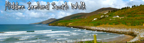
Hidden Ireland South Walk
Galway
Ireland
Enjoy astonishing cliffs that jut from the Atlantic, wildflowers that tickle your ankles and traditional Irish music and dance that will have you up on your feet. Hike your way through the south of hidden Ireland and encounter strange rock structures, quaint shops and villages, lovely coastal views, peaceful beach walks, historical structures and nights in comfortable accommodations.
Fully escorted by professional and experienced guides, this trek takes you through a wild yet serene piece of Ireland. Immerse yourself in the wildlife and greenery, explore ancient structures and find yourself charmed by the traditional way of like that this regions still follows. If you would like to discover the natural beauty on Ireland on your own two feet, then this trek is for you!
Tour Highlights
- The Cliffs of Moher
- Wild flowers of the Burren
- Unusual geology of the Burren
- Walk part of the Dingle Way
- Magnificent Kerry scenery
- A walk on magnificent Ventry Beach
- Traditional music
|
|
|
Rates and Dates for 2024
Rates include*:
Galway City pick-up and Dublin Airport drop-off; Accommodation; All land transport; 8 guided walks; Escort of full-time guide; Evening transportation to pubs / music; Entrance to Cliffs of Moher; Most meals
| A | 2024 | 9 day trip | 9d / 8n | €6000 | $6600 |
�����������������������������������������������������������������������������������������������������������������������������������������������������������������������������������������������������������������������������������������������������������������������������������������������������������������������������������������������������������������������������������������������������������������������������������������������������������������������������������������������������������������������������������������������������������������������������������������������������������������������������������������������������������������������������������������������������������������������������������������������������������������������������������������������������������������������������������������������������������������������������������������������������������������������������������������������������������������������������������������������������������������������������������������������������������������������������������������������������������������������������������������������������������������������������������������������������������������������������������������������������������������������������������������������������������������������������������������������������������������������������������������������������������������������������������������������������������������������������������������������������������������������������������������������������������������������������������������������������������������������������������������������������������������������������������������������������������������������������������������������������������������������������������������������������������������������������������������������������������������������������������������������������������������������������������������������������������������������������������������������������������������������������������������������������������������������������������������������������������������������������������������������������������������������������������������������������������������������������������������������������������������������������������������������������������������������������������������������������������������������������������������������������������������������������������������������������������������������������������������������������������������������������������������������������������������������������������������������������������������������������������������������������������������������������������������������������������������������������������������������������������������������������������������������������������������������������������������������������������������������������������������������������������������������������������������������������������������������������������������������������������������������������������������������������������������������������������������������������������������������������������������������������������������������������������������������������������������������������������������������������������������������������������������������������������������������������������������������������������������������������������������������������������������������������������������������������������������������������������������������������������������������������������������������������������������������������������������������������������������������������������������������������������������������������������������������������������������������������������������������������������������������������������������������������������������������������������������������������������������������������������������������������������������������������������������������������������������������������������������������������������������������������������������������������������������������������������������������������������������������������������������������������������������������������������������������������������������������������������������������������������������������������������������������������������������������������������������������������������������������������������������������������������������������������������������������������������������������������������������������������������������������������������������������������������������������������������������������������������������������������������������������������������������������������������������������������������������������������������������������������������������������������������������������������������������������������������������������������������������������������������������������������������������������������������������������������������������������������������������������������������������������������������������������������������������������������������������������������������������������������������������������������������������������������������������������������������������������������������������������������������������������������������������������������������������������������������������������������������������������������������������������������������������������������������������������������������������������������������������������������������������������������������������������������������������������������������������������������������������������������������������������������������������������������������������������������������������������������������������������������������������������������������������������������������������������������������������������������������������������������������������������������������������������������������������������������������������������������������������������������������������������������������������������������������������������������������������������������������������������������������������������������������������������������������������������������������������������������������������������������������������������������������������������������������������������������������������������������������������������������������������������������������������������������������������������������������������������������������������������������������������������������������������������������������������������������������������������������������������������������������������������������������������������������������������������������������������������������������������������������������������������������������������������������������������������������������������������������������������������������������������������������������������������������������������������������������������������������������������������������������������������������������������������������������������������������������������������������������������������������������������������������������������������������������������������������������������������������������������������������������������������������������������������������������������������������������������������������������������������������������������������������������������������������������������������������������������������������������������������������������������������������������������������������������������������������������������������������������������������������������������������������������������������������������������������������������������������������������������������������������������������������������������������������������������������������������������������������������������������������������������������������������������������������������������������������������������������������������������������������������������������������������������������������������������������������������������������������������������������������������������������������������������������������������������������������������������������������������������������������������������������������������������������������������������������������������������������������������������������������������������������������������������������������������������������������������������������������������������������������������������������������������������������������������������������������������������������������������������������������������������������������������������������������������������������������������������������������������������������������������������������������������������������������������������������������������������������������������������������������������������������������������������������������������������������������������������������������������������������������������������������������������������������������������������������������������������������������������������������������������������������������������������������������������������������������������������������������������������������������������������������������������������������������������������������������������������������������������������������������������������������������������������������������������������������������������������������������������������������������������������������������������������������������������������������������������������������������������������������������������������������������������������������������������������������������������������������������������������������������������������������������������������������������������������������������������������������������������������������������������������������������������������������������������������������������������������������������������������������������������������������������������������������������������������������������������������������������������������������������������������������������������������������������������������������������������������������������������������������������������������������������������������������������������������������������������������������������������������������������������������������������������������������������������������������������������������������������������������������������������������������������������������������������������������������������������������������������������������������������������������������������������������������������������������������������������������������������������������������������������������������������������������������������������������������������������������������������������������������������������������������������������������������������������������������������������������������������������������������������������������������������������������������������������������������������������������������������������������������������������������������������������������������������������������������������������������������������������������������������������������������������������������������������������������������������������������������������������������������������������������������������������������������������������������������������������������������������������������������������������������������������������������������������������������������������������������������������������������������������������������������������������������������������������������������������������������������������������������������������������������������������������������������������������������������������������������������������������������������������������������������������������������������������������������������������������������������������������������������������������������������������������������������������������������������������������������������������������������������������������������������������������������������������������������������������������������������������������������������������������������������������������������������������������������������������������������������������������������������������������������������������������������������������������������������������������������������������������������������������������������������������������������������������������������������������������������������������������������������������������������������������������������������������������������������������������������������������������������������������������������������������������������������������������������������������������������������������������������������������������������������������������������������������������������������������������������������������������������������������������������������������������������������������������������������������������������������������������������������������������������������������������������������������������������������������������������������������������������������������������������������������������������������������������������������������������������������������������������������������������������������������������������������������������������������������������������������������������������������������������������������������������������������������������������������������������������������������������������������������������������������������������������������������������������������������������������������������������������������������������������������������������������������������������������������������������������������������������������������������������������������������������������������������������������������������������������������������������������������������������������������������������������������������������������������������������������������������������������������������������������������������������������������������������������������������������������������������������������������������������������������������������������������������������������������������������������������������������������������������������������������������������������������������������������������������������������������������������������������������������������������������������������������������������������������������������������������������������������������������������������������������������������������������������������������������������������������������������������������������������������������������������������������������������������������������������������������������������������������������������������������������������������������������������������������������������������������������������������������������������������������������������������������������������������������������������������������������������������������������������������������������������������������������������������������������������������������������������������������������������������������������������������������������������������������������������������������������������������������������������������������������������������������������������������������������������������������������������������������������������������������������������������������������������������������������������������������
Minimum Deposit:
~$600.00 per person
* prices are per person based on double/twin occupancy
Transfer and Other Charges:
|
2024
|
Transfers are included at set times
|
€
0
|
$0
|
|
2024
|
Single supplement
|
€
800
|
$880
|
On Day 1 of the program, pick up is scheduled from Galway City for 12:00 pm (noon).
On the last day of the program, drop-off at Killarney Rail / Bus station for 12:00 pm (noon).
Rates do not include:
Dinners on Days 4, 5, and 6
Sample itinerary - subject to changes
The itinerary below is subject to change for varying reasons. Any changes made by the operator and / or the tour leaders will be in the interest and safety of all participants.
Day 1: Meet at Galway City. Hike Slieve Elva in the Burren
We will meet you at Galway City where your journey begins. We will head south to the Burren Region of County Clare – a huge plateau of limestone and shale aptly summed up with the words, “savage land, yielding neither water enough to drown a man, nor a tree to hang him, nor soil enough to bury him”. The Burren, also described as a strange lunar-like region of bare carboniferous limestone which occupies around one hundred square miles of County Clare. Our walk today is at the highest point in the Burren: Slieve Elva. We will be rewarded with great views across Galway Bay to the Aran Islands.
Alternative Walk Options: the full walk is 6 miles long, there is an alternative option of just 2-3 miles available.
Terrain: forest tracks, green road, stoney trails | Elev 300 ft.
Walking Distance 6 miles (9.7 km)
Overnight: Ballyvaughan or Lisdoonvarna in the Burren
Meals Included: Lunch and Dinner
Day 2: Morning hike in the Coastal Burren Area, Afternoon hike on the Beach
Today we will be accompanied by our local expert guide. He will take us to sites of botanical, geological and archaeological interest. This will include walking in two separate parts of the Burren with a break for lunch. The Burren region is famous for its flora: you will never see anything like the carpets of primroses, coastal displays of sea pinks, or the white flower of the blackthorn cascading over all the hedgerows. Rare and spectacular plants occur in abundance. Orchids grow everywhere in the Burren and 23 out of the 27 Irish species are to be found here.
Alternative Walk Options: there are two walks today: one in the morning and one in the afternoon. The first is approx. 5 miles, and the second is 2-3 miles.
Terrain: grassy and stoney track | Elev 700ft
Walking Distance 7 miles (11.2 km)
Overnight: Ballyvaughan, or Lisdoonvarna, County Clare
Meals Included: Breakfast, Lunch and Dinner
Day 3: Visit Cliffs of Moher & Travel to Newcastle West
The Cliffs of Moher; one of Ireland’s most notable sights. Towering 660 feet above the wild Atlantic, these cliffs are noted for abundant birdlife including puffins. We will begin our walk in the village of Doolin and hike six miles along the cliff path to the actual Cliffs of Moher.
Leaving County Clare, we will drive south to Newcastle West, in County Limerick stopping for a visit to the lovely village of Adare en route.
Alternative Walk Options: the full walk is 6 miles long, there is an alternative option of just 2-3 miles available.
Terrain: grassy and stoney track | Elev gain: 400 ft.
Walking Distance 6 miles (9.7 km)
Overnight: Newcastle West, County Limerick
Meals Included: Breakfast, Lunch and Dinner
Day 4: Dingle Peninsula
We will drive south from Newcastle West to Dingle Town. Stopping on the way, we will hike for a couple of hours along the spectacular Inch Beach. We will arrive in the late morning in Dingle.
Our first walk on the Dingle Peninsula will be along the coast past the old lighthouse, looking out across Dingle Harbour. We make our walk past dramatic cliffs and coves to Beenbawn and return by the same route.
Terrain: coastal paths | Elev 300 ft.
Walking Distance 4 miles
Overnight: Dingle, County Kerry
Meals Included: Breakfast and Lunch
Day 5: Hike at the far end of Dingle Peninsula at Ballydavid Head
We travel today to the western side of the Brandon Ridge to walk at Ballydavid Head, for one of the best walks on the Dingle Peninsula. We climb gently through moorland grass to reach a fine vantage point with expansive views of the surrounding hills, fields, mountains, sea and cliffs. This area could be described as a “photographer’s paradise”. We will take our time to take pictures, relax, and enjoy the views. We will then return to Dingle for some free time to browse the lovely shops and galleries.
Alternative Walk Options: stroll into Dingle town to visit the shops / galleries / restaurants.
Terrain: country lanes, coast path, moorland | Elev gain: 500 ft.
Walking Distance 6 miles (9.7 km)
Overnight: Dingle, County Kerry
Meals Included: Breakfast and Lunch
Day 6: Dingle peninsula from North to South
We will drive across the highest road pass in Ireland, the Connor Pass to reach the spectacular green valley of Magha na Bo. Our path leads through a beautiful steep-sided valley towards the pass at Beenbo Mountain. We climb gently beside the river and on to open heathland where we can find the elusive sundew and butterwort (insectivorous plants of the bog) and the feathery white flags of the bog cotton. We cross over the pass and follow a track to Annascaul village. We can visit the South Pole Inn: once owned by Tom Crean, one of the heroes of the Shackleton expedition to the South Pole.
Alternative Walk Options: stroll into Dingle town to visit the shops / galleries / restaurants.
Terrain: mountain track, bog, country lanes | Elev gain: 1100 ft.
Walking Distance 9 miles
Overnight: Dingle, County Kerry
Meals Included: Breakfast and Lunch
Day 7: Boat Journey across Killarney Lakes & Kerry Way Walk
We leave Dingle this morning to travel down to Killarney where we will be taken on a boat ride out across the Lakes of Killarney National Park. Disembarking at Lord Brandon’s Cottage we will stop for our picnic lunch before heading off to hike part of the Kerry Way in the heart of the mountains known as the MacGillycuddy’s Reeks.We will then travel further south to Kenmare, County Kerry.
Terrain: heath and moorland, woodland, boggy tracks | Elev 300 ft.
Walking Distance 4 miles (6.4 km)
Overnight: Kenmare, County Kerry
Meals Included: Breakfast, Lunch and Dinner
Day 8: Travel the Ring of Kerry & Kerry Way Walk
Today we will walk part of the Kerry Way across from Derrynane House and Beach to Abbey Island, over the sand. The views of the coast and mountains are spectacular. We can take a rest at a quiet cove and have lunch. The route then climbs gently above the bay with lovely sea views taking in Scarriff Island. We then return along the Kerry Way to Derrynane House where there will be time to explore the grounds.
Alternative Walk Options: the full walk is 6 miles long, there is an alternative option of just relaxing or strolling in the beautiful town of Kenmare.
Terrain: beach, stone paths, boggy tracks | Elev 600 ft.
Walking Distance 4 miles (9.6 km)
Overnight: Kenmare, County Kerry
Meals Included: Breakfast, Lunch and Dinner
Day 9: Departure
We must say Goodbye to Ireland after our drive back to Killarney.
Meals Included: Breakfast
Note: Many clients come on a tour who wish to do very little hiking. Every day there are alternative options such as sight-seeing, relaxing, reading, painting, listening to Irish traditional music, and generally just soaking up the Irish atmosphere. You can opt out of the hiking on any day! All our accommodations are based in scenic locations, so you are very welcome to just remain “home” for the day.
Meeting:
Galway
Airport:
Shannon airport
Transfer:
Galway
On Day 1 of the program, pick up is scheduled from Galway City for 12:00 pm (noon).
On the last day of the program, drop-off at Killarney Rail / Bus station for 12:00 pm (noon).
|
Tack:
|
|
|
|
Horses:
|
|
|
|
Pace:
|
|
Easy pace. Can skip many of the hikes if preferred. ~6-11 miles per day.
|
|
Level:
|
|
 (2
to
3
out of 5) Easy
(2
to
3
out of 5) Easy
|
|
Riders:
|
|
Min
5 riders
|
Max
12 riders
|
|
This holiday, guided by someone who really knows and cares for Ireland, is the best way to see this enchanting country; imagine yourself hiking (or walking) over Irish mountains, pausing by Irish lakes, drinking in Irish pubs and listening to traditional Irish music.
These hiking trips show you the best of Ireland, its picturesque scenery, the grandeur of its mountains, the warmth and hospitality of its people and the magic of their music. Call it an Irish walking holiday; a hiking vacation in Ireland; even a sabbatical - maybe you're researching Ireland, perhaps for a thesis or book; or perhaps you want to see the Ireland of your Irish ancestors. Call it any or all of these, but treat yourself to a tour of Erin's Isle anyway.
Our hiking tours of Ireland are fully escorted by experienced, professional guides. We travel through Ireland in groups of no more than twelve people. We will escort you on hikes through Ireland's most scenic trails, walk through undiscovered routes lined with extraordinary vistas.
Ireland has a lot to offer the walker: dramatic sea cliffs, high mountain ridges, quiet green roads, butter roads, fuchsia-lined lanes, heath and moorland, sweeping expanses of beach. And then there are the sleepy villages, oak woods, sky-blue lakes, torrential waterfalls and babbling brooks.
Ireland's climate ideally suits the walker as generally it rarely gets too hot to be uncomfortable. Rain and cloud-formations are what bring the interesting light patterns and rainbows. The Western coast and islands are known for magnificent sunsets.
Don't be surprised at the very few people you will meet whilst walking, after all, the entire population of Ireland is only around four million! Ireland is a birdwatcher's paradise with many rarities such as the corncrake. It is also a great place for botanists, especially the area of the Burren, Co. Clare.
Maybe the best attraction of all is the people, you'll never find another place like it for hospitality, friendliness, warmth, generosity, humor, love of life and love of the land.
Hiking Level
It is important that you are fit and at least a regular hiker / walker. When we do half day walks the distance covered could be from 4 to 9 miles, when we do full day walks the distances covered could be 6 to 13 miles. The pace is relaxed with time to enjoy your surroundings, take pictures, watch the birds, etc. Generally the terrain comprises of combinations of tracks, lanes, moorland, heath, coastal paths, beaches and mountain paths. You may choose not to walk on certain days, it's your holiday, there are always alternatives. You may prefer to relax at our accommodation, draw, paint, read, think...
Generally after a day of walking we can help ourselves to complimentary tea and coffee at our accommodation. We allow for some relaxation time before dinner. We have an official "Diary" which has been kept by previous groups and you may choose to make a contribution at the end of your day. After dinner there is nearly always the option of visiting the local pubs for some traditional music and dancing.
Passport and Visa Requirements:
Passport valid for at least three months beyond length of stay required by all except:(a) 1. persons born in the UK travelling direct from the UK (applicable to British passport holders only).Note: Wh. more
Dingle area
|
Month
|
Jan
|
Feb
|
Mar
|
Apr
|
May
|
Jun
|
Jul
|
Aug
|
Sep
|
Oct
|
Nov
|
Dec
|
|
Average High Temperature (°F)
|
52
|
51
|
53
|
56
|
60
|
64
|
66
|
67
|
65
|
60
|
55
|
53
|
|
Average Low Temperature (°F)
|
42
|
42
|
43
|
45
|
49
|
53
|
56
|
56
|
54
|
50
|
46
|
44
|
|
Average High Temperature (°C)
|
11
|
11
|
12
|
14
|
16
|
18
|
19
|
19
|
18
|
16
|
13
|
12
|
|
Average Low Temperature (°C)
|
6
|
5
|
6
|
7
|
9
|
12
|
14
|
14
|
12
|
10
|
8
|
7
|
|
Average Precipitation (days of rain)
|
20
|
16
|
17
|
13
|
13
|
13
|
13
|
14
|
15
|
18
|
20
|
19
|
Source: NOAA
Seasons
From April to October the usual forecast is sunshine and showers. Ireland’s weather is temperate and mild without extremes of temperature. It is rarely too hot for hiking, keeping a comfortable temperature suitable for the hills and valleys and coastal paths. However, sometimes the weather can be changeable and you will encounter four seasons in one day! The Irish sum up their climate this way: "If you don't like the weather, just wait five minutes." It's bound to change!
June is typically the driest month and the winter months of December and January the wettest.
We travel from one location to the next on a comfortable LDV mini-coach with 14 high-backed seats (rarely filled to full capacity so there is plenty of room to spread out). The height of the vehicle allows for excellent views over hedgerows, stone walls, etc. Your luggage is stored inside, not on a roof rack, so there is no risk of it getting wet. We spend from one to three nights in each area and walk the best parts before moving on to our next stop. When we travel between locations we make plenty of allowances for "comfort" stops and coffee / tea breaks. Our vehicles are fitted with stereo systems so you may like to bring along a music tape or two for the driving journeys.
The following items are essential:
- Good strong waterproof hiking boots
- Waterproof jacket
- Comfortable hiking trousers (jeans are not recommended at all as they are too hot in fine weather and too heavy if they get wet)
- Small day rucksack for lunch, drinks, coat etc.
- Water Bottle
- Gloves (even in summer it can get really cool in some hilly and coastal areas)
- Warm Hat
- Personal toiletries and medication
- General warm clothing such as sweaters, track suit bottoms (sweat pants), fleece jacket, etc.
- Sun cream / sun block / after sun cream
- Spending money in Euros (due to the remote nature of our accommodations, it is sometimes difficult to get to banks and cash machines).
- Credit cards are accepted everywhere.
The following items are suggestions:
- Shorts
- Waterproof trousers
- Camera
- Binoculars
- Flask (Thermos)
- Walking pole / stick
- Torch (flashlight)
- Book
- Alarm clock
- Drawing / painting equipment
- Swimsuit
- Insect repellent
- Your favourite remedy for blisters. (I highly recommend a product called “Compeed” which is available in most pharmacists. In the USA and Canada it may be sold under a different brand name. It is manufactured by Johnson and Johnson)
(Note: Only one suitcase per person please)
Cell phone rental is available and can be pre-booked through www.rentaphone-ireland.com
If you are travelling from the USA you may wish to check out unlocking your cell phone to use and Irish SIM card. Check out www.unlockitfree.com or www.bilemo.com/unlock
Sorry, no video is currently available for this tour.
*Important Notice: The following ratings have been submitted by guests and do not necessarily represent the views of Hidden Trails, its partners or employees.
Every care is taken to ensure accuracy but Hidden Trails is not liable for any errors or omissions.
..view other reports for different trips
���������������������������������������������������������������������������������������������������������������������������������������������������������������������������������������������������������������������������������������������������������������������������������������������������������������������������������������������������������������������������������������������������������������������������������������������������������������������������������������������������������������������������������������������������������������������������������������������������������������������������������������������������������������������������������������������������������������������������������������������������������������������������������������������������������������������������������������������������������������������������������������������������������������������������������������������������������������������������������������������������������������������������������������������������������������������������������������������������������������������������������������������������������������������������������������������������������������������������������������������������������������������������������������������������������������������������������������������������������������������������������������������������������������������������������������������������������������������������������������������������������������������������������������������������������������������������������������������������������������������������������������������������������������������������������������������������������������������������������������������������������������������������������������������������������������������������������������������������������������������������������������������������������������������������������������������������������������������������������������������������������������������������������������������������������������������������������������������������������������������������������������������������������������������������������������������������������������������������������������������������������������������������������������������������������������������������������������������������������������������������������������������������������������������������������������������������������������������������������������������������������������������������������������������������������������������������������������������������������������������������������������������������������������������������������������������������������������������������������������������������������������������������������������������������������������������������������������������������������������������������������������������������������������������������������������������������������������������������������������������������������������������������������������������������������������������������������������������������������������������������������������������������������������������������������������������������������������������������������������������������������������������������������������������������������������������������������������������������������������������������������������������������������������������������������������������������������������������������������������������������������������������������������������������������������������������������������������������������������������������������������������������������������������������������������������������������������������������������������������������������������������������������������������������������������������������������������������������������������������������������������������������������������������������������������������������������������������������������������������������������������������������������������������������������������������������������������������������������������������������������������������������������������������������������������������������������������������������������������������������������������������������������������������������������������������������������������������������������������������������������������������������������������������������������������������������������������������������������������������������������������������������������������������������������������������������������������������������������������������������������������������������������������������������������������������������������������������������������������������������������������������������������������������������������������������������������������������������������������������������������������������������������������������������������������������������������������������������������������������������������������������������������������������������������������������������������������������������������������������������������������������������������������������������������������������������������������������������������������������������������������������������������������������������������������������������������������������������������������������������������������������������������������������������������������������������������������������������������������������������������������������������������������������������������������������������������������������������������������������������������������������������������������������������������������������������������������������������������������������������������������������������������������������������������������������������������������������������������������������������������������������������������������������������������������������������������������������������������������������������������������������������������������������������������������������������������������������������������������������������������������������������������������������������������������������������������������������������������������������������������������������������������������������������������������������������������������������������������������������������������������������������������������������������������������������������������������������������������������������������������������������������������������������������������������������������������������������������������������������������������������������������������������������������������������������������������������������������������������������������������������������������������������������������������������������������������������������������������������������������������������������������������������������������������������������������������������������������������������������������������������������������������������������������������������������������������������������������������������������������������������������������������������������������������������������������������������������������������������������������������������������������������������������������������������������������������������������������������������������������������������������������������������������������������������������������������������������������������������������������������������������������������������������������������������������������������������������������������������������������������������������������������������������������������������������������������������������������������������������������������������������������������������������������������������������������������������������������������������������������������������������������������������������������������������������������������������������������������������������������������������������������������������������������������������������������������������������������������������������������������������������������������������������������������������������������������������������������������������������������������������������������������������������������������������������������������������������������������������������������������������������������������������������������������������������������������������������������������������������������������������������������������������������������������������������������������������������������������������������������������������������������������������������������������������������������������������������������������������������������������������������������������������������������������������������������������������������������������������������������������������������������������������������������������������������������������������������������������������������������������������������������������������������������������������������������������������������������������������������������������������������������������������������������������������������������������������������������������������������������������������������������������������������������������������������������������������������������������������������������������������������������������������������������������������������������������������������������������������������������������������������������������������������������������������������������������������������������������������������������������������������������������������������������������������������������������������������������������������������������������������������������������������������������������������������������������������������������������������������������������������������������������������������������������������������������������������������������������������������������������������������������������������������������������������������������������������������������������������������������������������������������������������������������������������������������������������������������������������������������������������������������������������������������������������������������������������������������������������������������������������������������������������������������������������������������������������������������������������������������������������������������������������������������������������������������������������������������������������������������������������������������������������������������������������������������������������������������������������������������������������������������������������������������������������������������������������������������������������������������������������������������������������������������������������������������������������������������������������������������������������������������������������������������������������������������������������������������������������������������������������������������������������������������������������������������������������������������������������������������������������������������������������������������������������������������������������������������������������������������������������������������������������������������������������������������������������������������������������������������������������������������������������������������������������������������������������������������������������������������������������������������������������������������������������������������������������������������������������������������������������������������������������������������������������������������������������������������������������������������������������������������������������������������������������������������������������������������������������������������������������������������������������������������������������������������������������������������������������������������������������������������������������������������������������������������������������������������������������������������������������������������������������������������������������������������������������������������������������������������������������������������������������������������������������������������������������������������������������������������������������������������������������������������������������������������������������������������������������������������������������������������������������������������������������������������������������������������������������������������������������������������������������������������������������������������������������������������������������������������������������������������������������������������������������������������������������������������������������������������������������������������������������������������������������������������������������������������������������������������������������������������������������������������������������������������������������������������������������������������������������������������������������������������������������������
Accommodations
This is a progressive tour so nights will be spent in different locations.
Description
All our accommodations have been carefully selected and are approved by the high standards of the Irish Tourist Board. We have chosen locations of outstanding natural beauty, so that you can enjoy the best of Irish rural life and scenery. You will enjoy top quality accommodation in small, family run guesthouses and hotels whilst being charmed by the hospitable and friendly hosts.
We stay in small hotels, guest houses, farmhouses, B & B's and occasionally castles.
Accommodation Itinerary - subject to changes based on availability
Night 1 & 2: Accommodation in Ballyvaughan or Lisdoonvarna
Night 3: Accommodation in Newcastle West
Night 4, 5 & 6: Accommodation in Dingle
Night 7 & 8: Accommodation in Kenmare
Room Occupancy
All rooms are en suite twin, double or single. Singles are available on request for a small supplement.
Meals:
All meals are included in your package except from dinner on Day 4, 5, and 6.
Each morning, in addition to the famous full Irish breakfast, there are alternative options available. Everybody loves the Irish soda bread, with creamy Irish butter. But for the more health conscious, you can be assured of plenty of fruit, juice, yogurts and cereals.
We take packed lunches for our lunch breaks during our walks. These are provided from our accommodation or from local delis.
Our evenings are a time for reviewing the day's activities and shared experiences on the hills. Evening meals are taken either in the places where we are staying or in local restaurants. You will be pleasantly surprised at the fine quality meals you will enjoy on your tour.
|
Tack:
|
|
|
|
Horses:
|
|
|
|
Pace:
|
|
Easy pace. Can skip many of the hikes if preferred. ~6-11 miles per day.
|
|
Level:
|
|
(2
to
3
out of 5) Easy
|
|
Riders:
|
|
Min
5 riders
|
Max
12 riders
|
|
This holiday, guided by someone who really knows and cares for Ireland, is the best way to see this enchanting country; imagine yourself hiking (or walking) over Irish mountains, pausing by Irish lakes, drinking in Irish pubs and listening to traditional Irish music.
These hiking trips show you the best of Ireland, its picturesque scenery, the grandeur of its mountains, the warmth and hospitality of its people and the magic of their music. Call it an Irish walking holiday; a hiking vacation in Ireland; even a sabbatical - maybe you're researching Ireland, perhaps for a thesis or book; or perhaps you want to see the Ireland of your Irish ancestors. Call it any or all of these, but treat yourself to a tour of Erin's Isle anyway.
Our hiking tours of Ireland are fully escorted by experienced, professional guides. We travel through Ireland in groups of no more than twelve people. We will escort you on hikes through Ireland's most scenic trails, walk through undiscovered routes lined with extraordinary vistas.
Ireland has a lot to offer the walker: dramatic sea cliffs, high mountain ridges, quiet green roads, butter roads, fuchsia-lined lanes, heath and moorland, sweeping expanses of beach. And then there are the sleepy villages, oak woods, sky-blue lakes, torrential waterfalls and babbling brooks.
Ireland's climate ideally suits the walker as generally it rarely gets too hot to be uncomfortable. Rain and cloud-formations are what bring the interesting light patterns and rainbows. The Western coast and islands are known for magnificent sunsets.
Don't be surprised at the very few people you will meet whilst walking, after all, the entire population of Ireland is only around four million! Ireland is a birdwatcher's paradise with many rarities such as the corncrake. It is also a great place for botanists, especially the area of the Burren, Co. Clare.
Maybe the best attraction of all is the people, you'll never find another place like it for hospitality, friendliness, warmth, generosity, humor, love of life and love of the land.
Hiking Level
It is important that you are fit and at least a regular hiker / walker. When we do half day walks the distance covered could be from 4 to 9 miles, when we do full day walks the distances covered could be 6 to 13 miles. The pace is relaxed with time to enjoy your surroundings, take pictures, watch the birds, etc. Generally the terrain comprises of combinations of tracks, lanes, moorland, heath, coastal paths, beaches and mountain paths. You may choose not to walk on certain days, it's your holiday, there are always alternatives. You may prefer to relax at our accommodation, draw, paint, read, think...
Generally after a day of walking we can help ourselves to complimentary tea and coffee at our accommodation. We allow for some relaxation time before dinner. We have an official "Diary" which has been kept by previous groups and you may choose to make a contribution at the end of your day. After dinner there is nearly always the option of visiting the local pubs for some traditional music and dancing.
Passports
Passport valid for at least three months beyond length of stay required by all except:
(a) 1. persons born in the UK travelling direct from the UK (applicable to British passport holders only).
Note: Whilst UK citizens do not require a passport or visa to enter Ireland, most carriers by air or sea now require some form of identification with photograph, usually a passport or driving licence with photo. Visitors should check what form of ID is required with the individual airline, ferry company or travel agent before travelling.
(b) 2. EU nationals holding a valid national ID card.
Note: EU nationals are only required to produce evidence of their EU nationality and identity in order to be admitted to any EU Member State. This evidence can take the form of a valid national passport or national identity card. Either is acceptable. Possession of a return ticket, any length of validity on their document, sufficient funds for the length of their proposed visit should not be imposed.
Passport Note
3. Imposition of a return ticket as a condition of entry is at the discretion of the Immigration Officer at point of entry.
Visas
Not required by all nationals referred to in the chart above for the following durations:
(a) nationals of EU countries for an unlimited period (nationals of EU countries wishing to stay for longer than three months must register with the Garda National Immigration Bureau).
(b) nationals of Australia, Canada and the USA for stays of up to 90 days.
Note: Nationals not referred to in the chart above are advised to contact the embassy to check visa requirements
| Passport Required? |
| British |
1 |
| Australian |
Yes |
| Canadian |
Yes |
| USA |
Yes |
| Other EU |
2 |
| Visa Required? |
| British |
No |
| Australian |
No |
| Canadian |
No |
| USA |
No |
| Other EU |
No |
| Return Ticket Required? |
| British |
No |
| Australian |
3 |
| Canadian |
3 |
| USA |
3 |
| Other EU |
No |
This information is not being updated on a regular basis. Hidden Trails does not
take any responsibility for the accuracy of the above information. Please, consult
the embassy or consulate for updated info.
|

|
|
|
Hidden Ireland South Walk
Tour Code:
ZZ-HKIRJ-05
9 days /
8 nights
Dates :
June to Sept
Trip Rating :

Level :

Difficulty Levels Explained
|
1. |
Easy
|
Easy pace and an average-to-sedentary level of fitness. You should be in good health and fit enough for full day of normal sightseeing and walking.
|
|
2. |
Easy to Moderate
|
An average level of fitness or some experience with the featured
activity is recommended.
|
|
3. |
Moderate
|
Requires you to have performed the featured activity regularly, with
some periods on challenging terrain. Activities are mandatory and
you may be traveling at high elevations. You need to be in good health and physical condition to enjoy these trips, with adequate muscular strength and cardiovascular endurance.
|
|
4. |
Demanding
|
You must be extremely physically fit and are expected to hike or
ride four to six hours over steep or more rugged terrain. |
|
5. |
Strenuous
|
Prolonged hiking/biking on moderate to difficult terrain (five to nine hours a day).
May include high altitude, rugged terrain etc.. |

Introduction
Day to Day Itinerary
Rates | Dates
Accommodation
Tack:
Horses:
Pace:
Easy pace. Can skip many of the hikes ...
Airport:
Shannon airport
Location on Google Map
Image Gallery
Image Slide Show
Customer Trip Rating
Climate
What To Bring
Download tour PDF 
|