|
|
|
|
|
|
|
|
|
|
|
|
|
|
|
|
|

Loading Content...
|
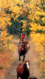
Horseback riding vacations and Equestrian Tours with Hidden Trails
Welcome to our horseback riding vacation website. Here you will find over 400 exciting equestrian tours all over the world with detailed descriptions, slide shows, videos, trip reports and more.
To make it easier for you, we have created a "TripFinder" where you can search for your horse vacation of a lifetime by entering the type of ride, the location, time period or riding level.
Or you can go direct to the country (Continent, Country ...) or the riding type ("Tours").
- If you are interested in other outdoor activities like walking tours, biking trips, sea kayak or maybe cruising the Galapagos Islands - go to our Outdoor Adventure Page.
We have categorized our riding holidays into different categories, so if you are looking for
ie a "Horse Drive", you can just select this section and select your trip from there.
Of course you have then the option to narrow it down further to the different countries.
We always give you the option to use other filters like "riding level" , "trip dates" or "price level".
Here is a list of our categories for you to chose from:
|
| Select by Activity: |
| Progressive Rides - |
riding tours with overnights in Inns and Lodges |
 |
| Stationary Rides - |
riding holidays with overnights at one Inn/Lodge |
| Riding Safaris - |
wildlife safaris on horseback |
| Horse Drives - |
moving a remuda of horses - some fast paced |
| Cattle Drives - |
true cattle drives and round-ups |
| Wilderness Rides - |
wilderness camping rides (vehicle supported) |
| Pack Trips - |
wilderness pack trips (pack horse supported) |
| Working Ranches - |
true working cattle ranches, estancias, haciendas |
| Guest Ranches - |
guest ranches, riding resorts, haciendas |
| Riding Clinics - |
improve your riding - train with the best |
| |
| Specialty Trips: |
| Short Getaways - |
short 2 to 5 day getaway riding holidays |
 |
| Ride & Fish - |
combine riding with excellent fishing opportunities |
| Ride & Cook - |
combine a riding holiday with a cooking course |
| Women Only - |
equestrian getaways for women only |
| Over 210 lbs - |
a selection of rides suited for riders over 210 lbs |
| Western Overseas - |
riding with Western tack on overseas trips |
| Gaited Horses - |
riding on smooth gaited horses |
| Family Trips - |
holidays for the whole family |
If you are considering a special horseback riding or outdoor vacation anywhere in the world, call us first and let our experienced staff match the perfect holiday with your dream. We will listen to you, and take the care to help you choose the best destination and adventure holiday.
Also check out our Outdoor trips:
Galapagos Cruises | Amazon Adventures
Walking Tours | Cycling Vacations | Canoeing Holidays | Kayaking Trips | MultiSport Vacations
|
|
Trips of the Week
and Special Offers
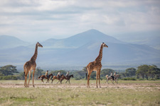 Arusha Riding Safari Tanzania, TanzaniaA safari in Tanzania is a must for those who love Africa and horses. Tanzania is one of Africa's main destinations for people passionate about the wild savannah. Arusha National Park, whose name derives from Warusha (the name of the local people of the region), offers a wide variety of flora and fauna in a pleasant setting. Join our amazing 7-night or 3-night horse safari for an unforgettable experience.
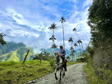 Coffee Region Explorer Colombia, Coffee ZoneTraverse the Colombian coffee axis, also known as the coffee triangle, on horseback. Travel across the 3 departments of Risaralda, Caldas and Quindio and escape into the most unspoilt parts of this region. Ride ridgetops with 360 degree views, canter through Andean cloud forests, cross rivers, swim in waterfalls and experience the warm welcome of Colombian hospitality. Your holiday starts with a day to relax, acclimatise and meet your horse at our stunning 150 year old ranch house.
|